All about the United States of America. English ESL/EFL Lesson Plans To teach the students about the USA in a geographical, historical, and cultural sense.
All about the United States of America

Lesson plans
Here you can find a wide range of full lesson plans to use in your classroom.
All of our lessons are designed around themes engaging and relevant to English ESL-EFL learners and can be used to complement your school curriculum, giving students an opportunity to develop their English language and skills in motivating and enjoyable ways.
These lesson plans focus on classroom games and activities oriented around meaningful practice of grammar items in English. The vast majority of the activities have been designed to be simple and easy to apply, without requiring much in the way of additional resources or materials. Wherever possible, games have been presented in a way that makes full use of any natural or genuine communicative aspects embodied in the grammar constructions, though while there is emphasis on understanding the grammar and its functional and communicative aspects, most of the games also highlight the importance of using the grammar accurately.
These lesson plans are intended as a starting point for teachers to adapt and build their own stock of in-class games and activities that can be applied relatively quickly and easily.
All about the United States of America
All about the United States of America. Here are 12 lesson plans on the USA
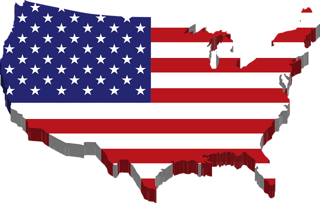
The United States of America Introduction
Warm-Up:
Ask the students to shout out what they know (or think they know) about the USA, and just write everything they say on the board. This will be a starting point for you to instruct, correct errors, and then to eventually get into your other lessons about the USA.
Presentation:
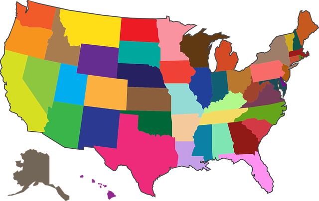
– It might be useful to have a map of the USA in your classroom somewhere so the class can get a visual of what and where you are talking about.
– Introduce them to the USA by giving them basic simple facts:
1. There are 50 states.
2. It is the 3rd largest country in population (after China and India).
3. It is the 4th largest in land area (after Russia, China, and Canada).
4. The USA won it’s independence in 1776 from the British.
5. Washington D.C. is the national capital and federal district for the
entire country.
Practice:
– After the students have copied down the above facts in their notebooks, have them then finish the hour writing out all the names of all 50 states. Make sure that they use correct spelling.
– Have the students put a mark next to the states they are familiar with or have heard of before, and have them star the states they have never heard of.
For those states that they may know something about have them write down what it is they know about it next to the state. Also, have the students put a mark next to the states they are interested in to
learn more about.
Homework:
– Have the students write down 5 questions they would like to find the answers out to or things they are just curious about so that these can be addressed in the upcoming lessons all concerning the USA.
The Western States (part 1)
Warm-Up:
Ask the students to share their questions that they did for homework and have this be a starting point for the exploration of the USA.
Presentation:
– Give your students the following vocabulary words for comprehension:
1. North =
2. West =
3. East =
4. South =
5. territory =
6. river =
7. railroad =
8. century =
9. canyon =
10. island =
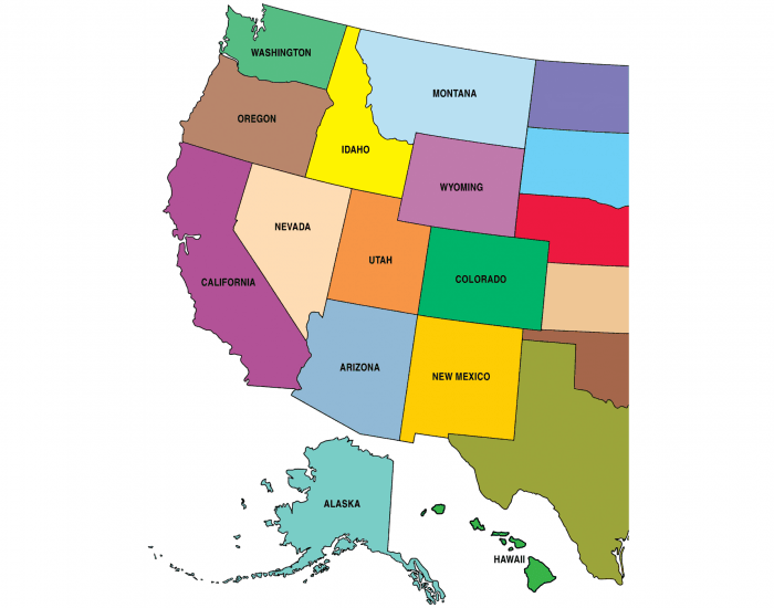
– Introduce them to the Western States by giving them basic simple facts:
1. The Western United States is made up of deserts, mountains, river
canyons, and great forests.
2. It is separated from the continental US by the Rocky Mountains.
3. Railroads were a huge factor in the development of the West.
– There are 11 states that make up the Western United States:
1. Washington
2. Nevada
3. Montana
4. Utah
5. Oregon
6. Colorado
7. Idaho
8. Arizona
9. Wyoming
10. New Mexico
11. California
– If it’s an option try to accompany the lesson with pictures.
Practice:
– Have the students copy down the above facts and names in their notebooks. Make sure that they use correct spelling.
– Have the students pick one of the eleven states to focus on. Divide them into groups according to their selected states and then have them use classroom resources: books, maps, or you the teacher to prepare a little information about the state.
– Have the students present to the class.
Homework:
– Have the students practice saying and spelling the first eleven states they have learned because they will need to know these well for the next lesson.
The Western States (part 2)
Warm-Up:
Ask the students to review what they learned in the previous lesson about the Western part of the United States.
Presentation:
– Review the 11 states that make up the Western United States:
1. Washington
2. Nevada
3. Montana
4. Utah
5. Oregon
6. Colorado
7. Idaho
8. Arizona
9. Wyoming
10. New Mexico
11. California
Practice:
– Cover the map up in your classroom (if you have one), and then draw an outline of one of the eleven Western States on the chalkboard to see if the student’s can recognize it by the shape.
– Do this for the remaining 10 states as well.
– Have the students unscramble the states names. Only write the scrambled part on the board.
– huta = utah
– iwemoexcn = new mexico
– mowgyin = wyoming
– oiarzna = arizona
– rlaicnafoi = california
– denava = nevada
– rlodaoco = colorado
– ntamano = montana
– gsniwatohn = washington
– hdaoi = idaho
– rgoeon = oregon
Homework:
– Have the students practice saying and spelling the first eleven states they have learned for review.
The Midwestern States (part 1)
Warm-Up:
Ask the students to review the names and locations of the eleven states in the Western part of the United States.
Presentation:
– Give your students the following vocabulary words for comprehension:
1. flat =
2. fertile =
3. Plain =
4. import =
5. export =
– Introduce them to the Midwestern States by giving them basic simple facts:
1. The Midwestern states are bordered by the Great Lakes to the North, the Rocky Mountains to the West, and the Appalachian Mountains to the east is a flat, fertile area known as the Great Plains.
2. Midwest produces more than half the world’s corn and enough wheat to make the U.S. the world’s largest exporter.
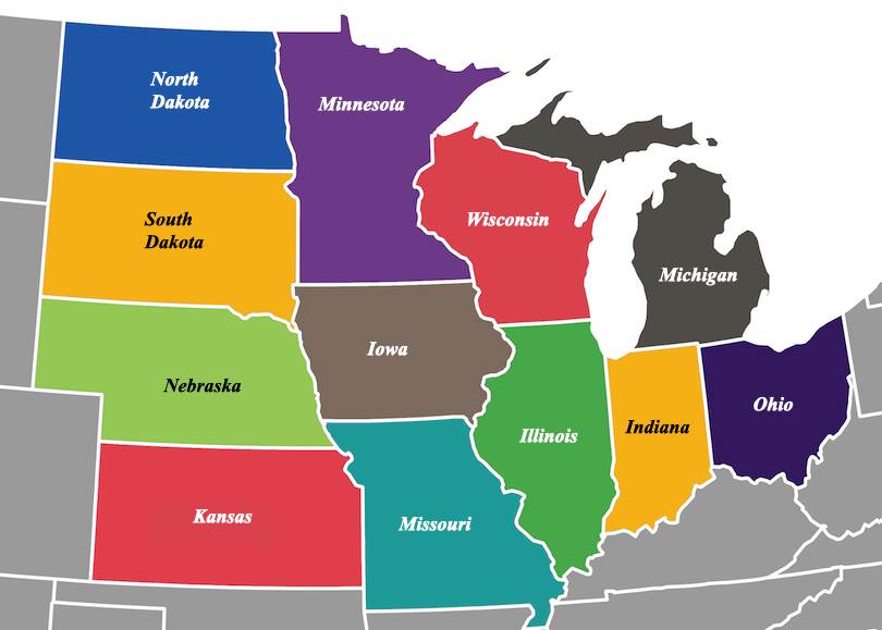
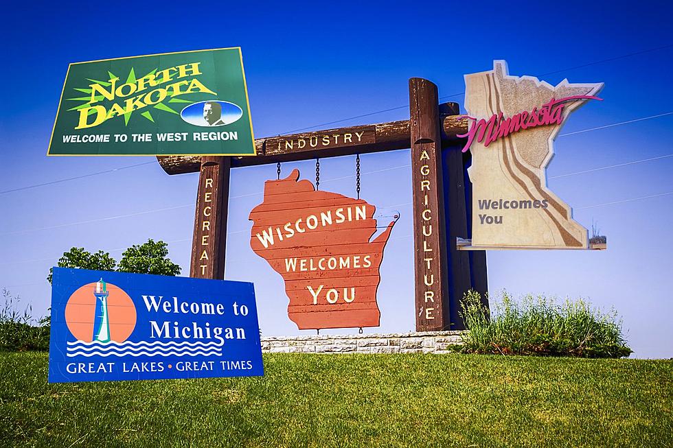
– There are 14 states that make up the Midwestern United States:
1. North Dakota
2. Missouri
3. South Dakota
4. Wisconsin
5. Nebraska
6. Illinois
7. Kansas
8. Michigan
9. Oklahoma
10. Indiana
11. Minnesota
12. Ohio
13. Iowa
14. Kentucky
– If it’s an option try to accompany the lesson with pictures.
Practice:
– Have the students copy down the above facts and names in their notebooks. Make sure that they use correct spelling.
– Have the students pick one of the fourteen states to focus on. Divide them into groups according to their selected states and then have them use classroom resources: books, maps, or you the teacher to prepare a little information about the state.
– Have the students present to the class.
Homework:
– Have the students practice saying and spelling these fourteen Midwestern states they have learned because they will need to know these well for the next lesson.
The Midwestern States (part 2)
Warm-Up:
Ask the students to review what they learned in the previous lesson about the Midwestern part of the United States.
Presentation:
– Review the 14 states that make up the Midwestern United States:
1. North Dakota
2. Missouri
3. South Dakota
4. Wisconsin
5. Nebraska
6. Illinois
7. Kansas
8. Michigan
9. Oklahoma
10. Indiana
11. Minnesota
12. Ohio
13. Iowa
14. Kentucky
Practice:
– Cover the map up in your classroom (if you have one), and then draw an outline of one of the fourteen Midwestern States on the board to see if the student’s can recognize it by the shape.
– Do this for the remaining 13 states as well.
– Have the students solve the crossword puzzle locating all 14 Midwest States.
Homework:
– Have the students practice saying and spelling the fourteen Midwest states they have learned for review.
All about the United States of America
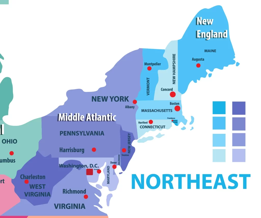
The NorthEastern and MidAtlantic States (part 1)
Warm-Up:
Ask the students to review the names and locations of the fourteen states in the Midwestern part of the United States.
Presentation:
– Give your students the following vocabulary words for comprehension:
1. populous =
2. region =
3. Colonist =
4. settle =
5. lighthouse =
– Introduce them to the NorthEastern and MidAtlantic States by giving them basic simple facts:
1. This is the most populated region in the USA.
2. The first people to arrive in the USA landed here in 1620 and they
settled in New Plymouth, Massachusetts.
3. There are many lighthouses along the coasts and inlets of this region.
4. Rhode Island is the smallest state in the USA.
5. Delaware was the first state to sign the Constitution.
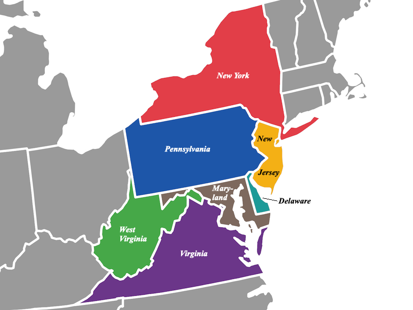
– There are 13 states that make up the NorthEastern and MidAtlantic United States:
1. Maine
2. Pennsylvania
3. New Hampshire
4. New Jersey
5. Vermont
6. Delaware
7. New York
8. Maryland
9. Massachusetts
10. West Virginia
11. Rhode Island
12. Virginia
13. Connecticut
– If it’s an option try to accompany the lesson with pictures.
Practice:
– Have the students copy down the above facts and names in their notebooks. Make sure that they use correct spelling.
– Have the students pick one of the thirteen states to focus on. Divide them into groups according to their selected states and then have them use classroom resources: books, maps, or you the teacher to prepare a little information about the state.
– Have the students present to the class.
Homework:
– Have the students practice saying and spelling these thirteen NorthEastern and MidAtlantic states they have learned because they will need to know these well for the next lesson.
The NorthEastern and MidAtlantic States (part 2)
Warm-Up:
Ask the students to review what they learned in the previous lesson about the NorthEastern and MidAtlantic part of the United States.
Presentation:
– Review the 13 states that make up the NorthEastern and MidAtlantic States:
1. Maine
2. Pennsylvania
3. New Hampshire
4. New Jersey
5. Vermont
6. Delaware
7. New York
8. Maryland
9. Massachusetts
10. West Virginia
11. Rhode Island
12. Virginia
13. Connecticut
Practice:
– Cover the map up in your classroom (if you have one), and then draw an outline of one of the thirteen Northeastern and Midatlantic States on the chalkboard to see if the student’s can recognize it by the shape.
– Do this for the remaining 12 states as well.
– Have the students unscramble the states names. Only write the scrambled part on the board.
– nwiergitasvi = west virginia
– sywerejne = new jersey
– nayvapnlines = pennsylvania
– mervnot = vermont
– nctiecutnoc = connecticut
– rwkeyno = new york
– ganirivi = virginia
– lreadawe = delaware
– nydamral = maryland
– miena = maine
– dahnsolrdie = rhode island
– priemhwasenh = new hampshire
– stcusasmathes = massachusetts
Homework:
– Have the students practice saying and spelling the thirteen states they have just learned for review.
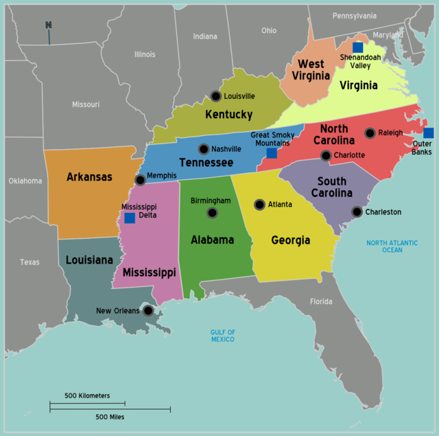
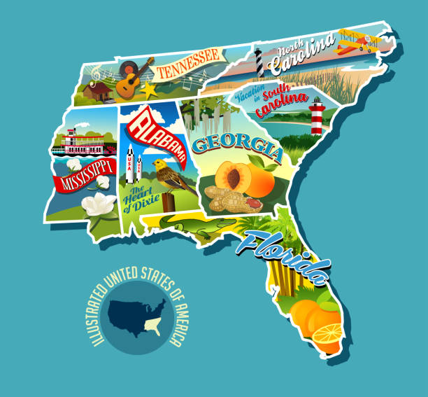
The Southern States (part 1)
Warm-Up:
Ask the students to review the names and locations of the Northeastern and Midatlantic states.
Presentation:
– Give your students the following vocabulary words for comprehension:
1. coast =
2. farm =
3. cotton =
4. tobacco =
5. agriculture =
6. industry =
7. oil =
8. iron =
9. steel =
10. elevation =
– Introduce them to the Southern States by giving them basic simple facts:
1. The Southern States stretch from the Atlantic Coast to Texas.
2. This part of the country used to be entirely farm based, but now it also produces numerous other industrial materials.
3. Texas once used to be a part of Mexico and it has more farmland than any other state.
4. The first battle of the Civil War was fought in South Carolina at Fort
Sumter.
5. Louisiana has the lowest elevation of any state in the USA.
– There are 10 states that make up the Southern part of the United States:
1. Texas
2. North Carolina
3. Arkansas
4. South Carolina
5. Louisiana
6. Georgia
7. Tennessee
8. Mississippi
9. Alabama
10. Florida
– If it’s an option try to accompany the lesson with pictures.
Practice:
– Have the students copy down the above facts and names in their notebooks. Make sure that they use correct spelling.
– Have the students pick one of the ten states to focus on. Divide them into groups according to their selected states and then have them use classroom resources: books, maps, or you the teacher to prepare a little information about the state.
– Have the students present to the class.
Homework:
– Have the students practice saying and spelling these ten Southern states they have learned because they will need to know these well for the next lesson.
The Southern States (part 2)
Warm-Up:
Ask the students to review what they learned in the previous lesson about the
Southern part of the United States.
Presentation:
– Review the 10 states that make up the Southern part of the United States:
1. Texas
2. North Carolina
3. Arkansas
4. South Carolina
5. Louisiana
6. Georgia
7. Tennessee
8. Mississippi
9. Alabama
10. Florida
Practice:
– Cover the map up in your classroom (if you have one), and then draw an outline of one of the ten Southern States on the board to see if the student’s can recognize it by the shape.
– Do this for the remaining 9 states as well.
Homework:
– Have the students practice saying and spelling the ten states they have just learned for review.
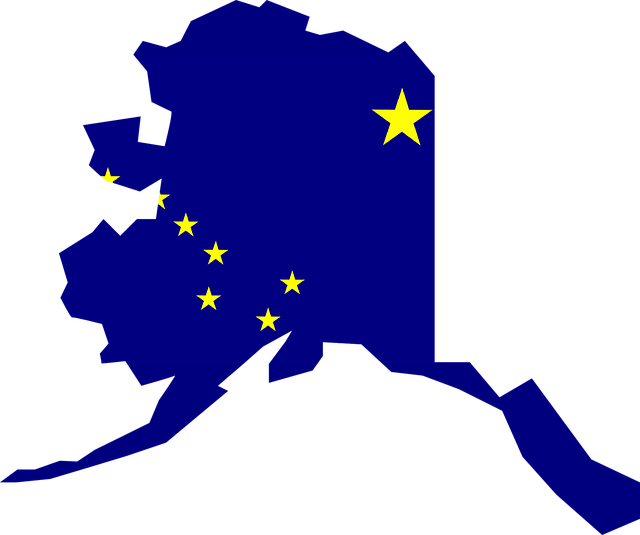
Alaska
Warm-Up:
Ask the students to review the names and locations of the Southern states.
Presentation:
– Give your students the following vocabulary words for comprehension:
1. eskimo =
2. union =
3. frontier =
4. cold =
5. fishing =
6. igloo =
7. coastline =
– Introduce them to Alaska by giving them basic simple facts:
1. It is located in North America’s farthest nothwest corner.
2. It is the largest state in the USA, being twice the size of Alaska.
3. It has a longer coastline than all the other states combined.
4. It has the highest mountain in North America (Mt. McKinley).
5. It was the 49th state to join the union in 1959.
– If it’s an option try to accompany the lesson with pictures.
Practice:
– Have the students copy down the above facts into their notebooks. Make sure that they use correct spellings.
– Have the students focus on Alaska and by using the classroom resources: books, maps, or you the teacher have them each prepare some information about this state.
– Have the students present to the class.
Homework:
– Have the students practice saying and spelling all of the states they have learned up to this point.

Hawaii
Warm-Up:
Ask the students to review the names and locations of all the states learned up to this point.
Presentation:
– Give your students the following vocabulary words for comprehension:
1. Pacific Ocean =
2. chain =
3. pineapple =
4. volcano =
– Introduce them to Hawaii by giving them basic simple facts:
1. Hawaii was the last state added to the USA in 1959.
2. Hawaii is made up of 132 islands that create a chain through the Pacific Ocean 1,500 miles long.
3. There are both active and inactive volcanoes on these islands.
4. The primary industry in Hawaii is tourism followed by agricultural
productions of pineapples, coffee, and vegetation.
5. The attack at Pearl Harbor is notable for forcing the US into WWII.
– If it’s an option try to accompany the lesson with pictures.
Practice:
– Have the students copy down the above facts into their notebooks. Make sure that they use correct spellings.
– Have the students focus on Hawaii and by using the classroom resources: books, maps, or you the teacher have them each prepare some information about this state.
– Have the students present to the class.
Homework:
– Have the students practice saying and spelling all of the 50 states that they have now been fully exposed to.
The United States of America Wrap-Up
Warm-Up:
Ask the students to shout out what they now know about the USA, and write down everything they say, on the board. This will be a way for you to what they have learned over the course of the past few weeks exploration in the US.
Presentation:
– Review with your students the basic facts of the USA.
– Have them list all the regions of the United States:
1. Western
2. Midwestern
3. Northeastern and Midatlantic
4. Southern
5. Alaska and Hawaii
– Then have them tell you some of the basic facts they were taught concerning each area. Also, let them add in anything interesting that they found out in their works and studies about any particular region or state.
– Review all the states on the map, so that they are familiar with them visually.
Practice:
– After the review of the United States map have each student make their own map (drawn to scale in their notebooks) so that they can then take away their own personalized map which they now know and understand a little bit better.
Homework:
Have the students finish this task at home, unless you want to make it an “only in-class” project.
All about the United States of America
All about the United States of America. Also Check out these resources on the United States